
Agriculture in the Ukraine War 2024
Ukraine War: Almost 7% Less Arable Land – Consequences of the War for Agriculture Today
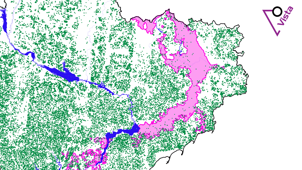
Vista GmbH, a subsidiary of BayWa AG, is using state-of-the-art technology to analyse how the Russian war of aggression is affecting agricultural production in Ukraine in the second year of the war. Among other things, almost 7% of the arable land is no longer used for agriculture and the course of the front is clearly visible on the cultivation maps.
-
Last year, around 6.5% of the land along the front line that was previously used for agriculture fell out of use.

At a glance
- Ukraine is currently losing 6.5% of its arable land due to war
- Analysis of satellite data shows the course of the front from an agricultural perspective
- Dam break leaves 52% of fields in Kherson oblast without water
Cultivation data makes war zone visible
With the help of satellite data, among other things, the Vista scientists determine which crops were grown in which region and on which area. The cultivation of spring and winter barley, grain maize, rapeseed, sunflower and wheat was observed. The PROMET physical plant growth model developed by Vista allows detailed forecasts of the yields of the observed crops. Last year, around 6.5 per cent of the former agricultural land along the front line fell out of use.
Satellite images show the difference between the years 2021 and 2023
The images show vegetation in places where fields used to be discernible. This is a sign that there is currently no field cultivation in these places. From an agricultural perspective, the front line along which Ukrainian and Russian troops are currently facing each other becomes visible. The data and maps also show that the fields in the Russian-occupied areas are still being cultivated.


2023 was a good harvest year in Ukraine despite the lack of arable land. In total, the harvested quantity is even in line with the harvests of the pre-war years: harvests of between 75 and 100 million tonnes were recorded from 2017 to 2021. In 2023, the harvest was around 82 million tonnes*.
*Includes the production of the fruit types calculated by Vista for the whole of Ukraine, including the Russian-controlled parts of the country excluding the Crimean peninsula.
Dam blasting affects irrigation in Kherson
In June 2023, the dam wall of the Kakhovka reservoir was blown up – most likely by Russian troops. The water from the reservoir was subsequently used to irrigate agricultural land in the Kherson oblast, among other things. A comparison of satellite images from 2021 with images from 2023 now shows that the extent of the irrigated area was 52% smaller. The white area in the image shows parts of the dry reservoir.
-

These are the artificially irrigated areas in Kherson Oblast 2021. -
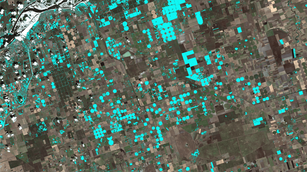
The same area in 2023 for comparison: Due to dam blasting, the proportion of irrigated land decreased by 52%.

